Local Outposts
Why This Map is Static (The Tracking-Free Infrastructure)
On almost any other website, a directory page like this would feature an embedded interactive map widget from a corporate tech monopoly like Google Maps.
We explicitly refuse to use them.
When a website embeds a Google Map, that widget acts as a digital surveillance outpost. The moment your browser loads it, Google instantly injects third-party tracking cookies into your device, harvests your IP address, logs your physical location, and links your visit to their global advertising profile. You become the product just for looking at a local directory.
To maintain 100% digital privacy for every visitor, this page uses a completely different architecture:
- Open-Source Mapping: We pulled this layout from OpenStreetMap, a community-driven, non-corporate project built on open data.
- Static Server Hosting: We manually captured a snapshot of the grid and uploaded it purely as a flat, static image file hosted on our own independent server.
- Manual Hand-Marking: Every single location indicator was drawn onto the image by hand, completely offline.
- Structured Cross-Street Directory: Directly below the visual map, we have formatted a clean, text-based index of every outpost’s exact intersections and landmarks. This provides an easily scannable, accessible guide so you can find the coordinates instantly without relying on a graphic alone.
Because this map and directory are simple, flat elements with no scripts or external communication pipelines, it is physically impossible for them to track your coordinates, read your browser data, or feed an advertising algorithm. You can navigate the physical outposts of this community knowing your digital footprint is completely invisible.
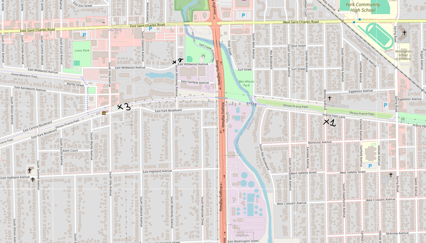
Structured Cross-Street Directory
- Outpost 01: On East side of Berkley Ave; just North of Prairie Path Ln [Elmhurst]
- Outpost 02: S Monterey Ave & E Wildwood Ave near Rotary Park and Salt Creek Trail [Villa Park]
- Outpost 03: Rotary Club Playground [Villa Park]
Taking Control: A Recommendation for Open-Source Tools
The decision to use OpenStreetMap here is part of a larger, vital philosophy: we highly recommend that everyone transition their daily digital lives toward Free and Open-Source Software (FOSS). When you use proprietary software built by corporate tech giants, you are trapped in a walled garden where the code is hidden, user data is harvested, and profit is the only metric of success. Open-source software completely flips this dynamic.
Embracing FOSS tools provides three massive, undeniable benefits:
- True Digital Privacy & Transparency: Because the underlying source code of FOSS tools is entirely public, it is constantly audited by independent developers worldwide. There are no hidden backdoors, no secret tracking algorithms, and no corporate data-harvesting operations buried in the software. You know exactly what the program is doing.
- Community Over Profit: Open-source projects are built, maintained, and improved by community collaboration, not by corporate boards looking to monetize your attention. The software exists solely to serve its function and help the user, completely free from targeted advertising, paywalls, and corporate gatekeepers.
- Complete User Autonomy: When you use open-source tools, you truly own your digital space. You are not forced into mandatory updates that degrade your privacy, your software cannot be abruptly cancelled or locked away behind a subscription fee, and you regain total control over your own hardware and data.
Building an independent community starts with choosing independent infrastructure. By rejecting corporate surveillance and actively adopting open-source alternatives—whether it is your operating system, your browser, or your local maps—you reclaim your digital agency and help build a web that belongs to the people, not the monopolies.